Grand Forks’ First Roundabout

For those of us excited about new things in town, or just for those excited to see people get totally confused while driving, here’s some news: according to WDAZ, Grand Forks is getting a roundabout:

The city will turn the intersection of 24th Avenue South and South 34th Street into a roundabout. The only similar one here in town is currently at the airport. [“similar” because it’s more of a wide spot in the road than a roundabout; one additional road merges through the circle to exit the airport.]

Construction is scheduled to begin next summer and it’s estimated to cost more than $500,000. Federal funds will cover 80 percent and the city will pay the other 20 percent. 

There has been increased traffic along 24th Avenue South and drivers trying to turn onto that street have experienced more delays and traffic congestion.

Roundabouts, traffic circles, and rotaries (not all the same thing), are obviously confusing to a driver or cyclist who is not familiar with how they work, but then again, so is driving around any new kind of structure or local custom.  People will get used to it, and we’ll get where we’re going faster, without having to waste money and electricity on signals (or time and fuel sitting at a stop sign or light).

My only real criticism of this plan is that it might encourage faster driving through the 25 mph residential area to the northwest.  Thoughts?


View Larger Map

Quickie: Dakota Student and Sidewalks

This editorial in the Dakota Student is from back in April, but it suggests one more way in which UND and Grand Forks can agree on something in the future–if both entities agree to create a unified complete streets transportation policy.

The thought arises at a moment such as this as to the importance of sidewalk maintenance and safety. Obviously the road is worthy of cars and loading trucks, but when was the last time the cobblestones were inspected or fixed? This area might not be used for car travel, but students consistently navigate these regions.

Not something you would typically expect from a student newspaper, is it?

ND is 49th out of 50 states for “bicycle friendliness”

ND: at the bottom of the 2012 League of American Bicyclists state rankings.

The League of American Bicyclists have come out with their 2012 state rankings, and North Dakota managed to beat out Arkansas for the 49th most-bicycle-friendly state.  As one commenter in on the Facebook group BIKE FARGO 365 put it, “not surprising!”  The state scorecard can be found here or linked at the bottom of the state ranking page..

Why exactly is this not surprising?  The League is pretty clear where we’re lacking, and pretty clear on what we need to do to improve.  North Dakota has failed to achieve any of the “Top 10 Signs of Success” regarding cycling and clearly needs a statewide Complete Streets policy.  But let’s step back a bit: sure, North Dakota as a whole isn’t going to compete with our neighbor Minnesota (#2, home to Minneapolis, just picked for best bikeability by WalkScore) or with Oregon (#1, home to Portland, this year’s best bike-friendly city according to Bicycling Magazine), but I don’t think we need to try for that right now.  What we can focus on is doing something local, and doing something now.

Each of the “Top 10 Signs of Success” can be achieved here in Grand Forks just as easily (or even more easily) than they can at the state level.  The same goes for Fargo, and for Bismarck and Minot.  I’m not trying to discount the other cyclists in the state, but lobbying for “bike friendliness” (as part of a greater Complete Streets initiative) might have a greater effect in the places where cycling is most viable as a transportation option: cities and large towns.  Grand Forks can be more nimble than the state in enacting policies that support all forms of transportation, and what we succeed at can be used as a model for the rest of the state.

Which of the “Top 10 Signs of Success” do you think are the most achievable in Grand Forks?

“Top 10 Signs of Success” from North Dakota’s 2012 League of American Bicyclists scorecard.

Grand Forks bikeshare survey results are out

Just a quick post to let people digest these responses.  The results are available as a PDF here, including all responses, not just aggregate data.  An FAQ PDF (which many survey respondents appear not to have read) is available from the Greater Grand Forks Greenway here.

Update: WDAZ had a story on this last night which thankfully details the type of system we might have here.
 

Closing University Avenue

One of the best things about going to a small residential university for my undergraduate degree was the lack of cars on campus.  The campus was small, there were parking lots on the outskirts (near most of the dorms), and you walked or rode a bicycle everywhere.  It was a given.  The campus was small enough to make this feasible.  It’s not that there were no vehicles at all–delivery trucks and the like would drive through in the early morning, the streets were plowed during the winter, and on move-in and move-out day you could bring your vehicle in to move your stuff–but for the students, we just had to deal with the lack of motorized transportation.

The Grand Forks/East Grand Forks Metropolitan Planning Organization is looking to do a similar thing for part of the University of North Dakota, reports the Grand Forks Herald.  They have released a report (which I have not located yet) proposing the closing of University Avenue between Columbia Road to the east and Stanford Road to the west (see image from the Herald website) in order to reduce pedestrian/motorist interactions, promote walking and cycling, and reduce emissions from motor vehicles.

Image from the Grand Forks Herald.

This proposal is notable for its daring and progressiveness.  This might be the first instance of closing streets for the sake of pedestrians in Grand Forks history.  There are strong criticisms, however I think they can be mitigated.  Two in particular stand out: emergency vehicle access and perceived increased congestion.

Emergency vehicle access worries are due to the use of University Ave as a route for fire trucks and ambulances, but “closed to personal vehicles” does not mean “closed to emergency vehicles.”  Allowing these vehicles access to University Ave, as long as even one lane is left clear for service, might even decrease response times due to not having to wait for automobile traffic to get out of the way.

Perceived congestion is a more difficult nut to crack, but I propose an initial tradeoff to help people understand the value of this street closure: limited hours of operation.  Larger cities do this all the time–drive into Washington, D.C. some morning and you’ll see whole residential streets change one-way direction–and people learn how it works.  Close University Avenue between 8 AM and 4 PM every day (perhaps with gates) except to service and emergency vehicles for a trial semester, study the effects, and use those data to shut it down completely.

Again, I’m very excited about this plan because it opens up new possibilities.  Street parties.  Street vendors (allowing off-campus restaurants to set up shop for lunch).  More space for people on foot and bicycles.  Less noise, traffic, and emissions for everyone.  What other opportunities do you see?
 

More Coverage of Possible Bikesharing System

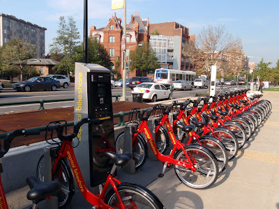
Is something similar to Capital Bikeshare coming to Grand Forks, North Dakota?
(Photo by Daquella manera under a CC-Attribution license.)

Today’s editorial in the Herald has a few examples of similar systems (not just bikeshares) in place that are run by the government instead of the private sector and is generally supportive of the city considering (or even trying out) the idea.

The original story has already gathered over 80 comments, both for and against, but a number of those comments (as always) have to deal with the same tangential issues that always come up: how much the Alerus center cost, how bad the smell from Crystal Sugar is sometimes, and how people like to argue on the Internet.  I’m not going to count up the number in favor and against because I think the sample isn’t representative; the official survey closes today at five and I’m hoping for results next week.

Interestingly enough, New York City is only slightly ahead of us on the bikesharing front and are choosing where to place stations for a July launch.  They are following Boston, Denver, and Washington, D.C. as another large U.S. city providing this service as a partnership with a private company.  University of California, Irvine (about half the number of students as Grand Forks has people) has their own system.

Wikiposedly (and I have not had time to check), government-run systems do require subsidies in one form or another, typically through advertising on the bikes or sharing stations, however these monetary costs can be made up in other ways that benefit all residents: less automobile congestion, more exposure to the outdoors, more exercise, a stronger sense of community and, most importantly, transportation options.  Add to this the strong support Secretary of Transportation Ray Lahood has shown for cyclists and pedestrians, it seems like we may finally be entering an age where non-motorists can claim their space on the street as equal.

I’m not sure that bikesharing in Grand Forks will work, but the fact that we’re even looking into it is good news.  Who knows?  We could get something Fargo doesn’t have.

Columbia Road to be Widened

According to the Grand Forks Herald, Columbia Road will be widened to six lanes after a vote last week by the city council.

In another Herald article, we’ve heard city council member Tyrone Grandstrand suggest a six-lane option is overkill based on traffic patterns from the last ten years:

‘Grandstrand said the city should pursue projects that support mixed business and residential development and planning that supports public transportation rather than expect traffic levels to keep going up on business corridors.
“We’re going to have less traffic on Columbia and everywhere else,” he said.’

[Added 2012-04-09]
Grandstrand posted details of the traffic study in the Herald comments section:

I voted against 6 lanes but along with everyone else in Grand Forks I believe Columbia needed fixing a long time ago.  Columbia road traffic decreased by over 20% from 2000 to 2010. Along with traffic generally in Grand Forks, so people didn’t just pick a different road to drive on.  4 lanes, with intersection upgrades and some use of technology would have been just as effective and 1.1 million dollars cheaper. 

[end add]

The proposal presented to the city council can be found here (.pptx) and describes two phases of widening to occur: the first from DeMers Avenue to 11th Avenue South in 2013, the second from 11th Avenue South to 14th Avenue South in 2014.  The presentation contains a brief description of the current non-motorized facilities along this stretch of Columbia Road, which include a sidewalk to the east and a wider shared-use path to the west.

No official discussion has been heard yet of on-street bicycle lanes as part of this project.  There are four shared-use/driveway/street intersections between the Columbia Road/DeMers Avenue overpass and 14th street south, a distance of about half a mile.


Changes to First Avenue North

This one should be quick. I noticed on my way into school this morning that the signs that have, for so long, dedicated Thursdays to a street free of cars (“No Parking Thursday 8 AM – 4 PM”) seem to be gone along 1st Ave N. Additionally, on the EERC end of the street (between 22nd and 23rd street at least) there are new “No Parking This Side of Street” signs on the south (eastbound) side of the street. 

I was considering that maybe this move was a way to save money by not cleaning/plowing this street, but it doesn’t leave the city a time in which to sweep or plow if it is necessary. I’m thinking now that the removal of parking on one side of the street (if in fact it goes all the way to South Washington) might be a move to encourage traffic flow along 1st Ave in addition to 2nd Ave (which is the high-traffic and quite narrow next street over).

Anyway, what do I know? Hopefully someone can find an answer. If more traffic is going down 1st Avenue, we need stop signs on all the cross streets so people don’t die.


View Larger Map

Phone Photos

0618112034a Took only a few photos this weekend with my phone, so you can probably assess the quality right there. If you think about it though, phone photography is really just another way of expression, and I don’t think it always means “I was too lazy to pull out my real camera” or even “I can’t afford a real camera.”

0618112034a Took only a few photos this weekend with my phone, so you can probably assess the quality right there. If you think about it though, phone photography is really just another way of expression, and I don’t think it always means “I was too lazy to pull out my real camera” or even “I can’t afford a real camera.” I think the point behind such “low quality” photography is that the situation was meaningful enough for me to try to capture what was going on. (“Low quality” is another concept that could be discussed forever: when the first digital cameras came out I was taking photos that were 640×480, but it allowed me to shoot as many as I wanted for free. What will we be calling “low quality” in the future?) I thought they were cool, so I’d like to share them. In other news, I’m considering moving [I have moved, 2014-02-04] my Blogspot blog (which has been up seemingly forever at http://protichnoctem.blogspot.com) to this Drupal website in order to consolidate things. I would probably leave the blog up as an artifact and a link to here, but this would also mean changing some Google Account settings around. I’d welcome any feedback on the idea. I used to host that blog on my Geocities (remember them?) account back in high school, so this isn’t such a bizarre concept. They do take care of server stuff for you though. 0618112034 0618112034b 0618112035 0618112039 0618112039a

[portfolio] END-SPAR 2011 poster

The background to the 2011 END-SPAR (Extreme North Dakota Spring Primer Adventure Race) poster was an idea Andy Magness had that he hired me to put together. I couldn’t find a good shoe image so I took a photo of my own Inov-8 show to throw on there.

Flower image: 1st Crocus by KitAy on Flickr.
ENDracing logo: ENDracing.com

All text is by Andy.