Snapshot: Crossing at DeMers Ave/S. Columbia Rd Interchange

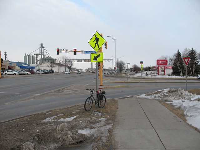
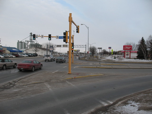
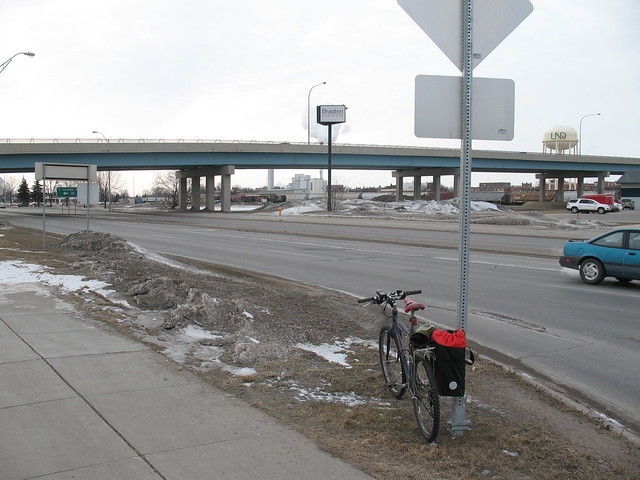
Trying to keep the words to a minimum, but here is an intersection in Grand Forks that I find particularly worrisome, especially for people to whom cycling/commuting is new. This crossing is the primary avenue between the University of North Dakota (to the north) and points to the southeast. The protected sidewalk on the S. Columbia Rd. overpass is used by riders because the traffic on the often exceeds 35 mph and people are not used to cyclists. See map at bottom of post.

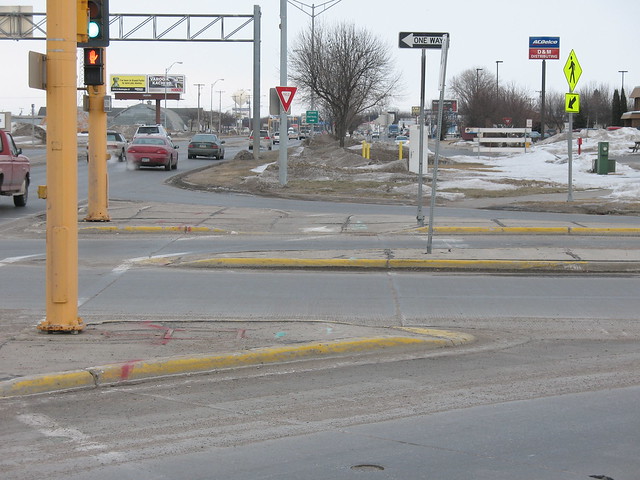
Most problematic: drivers merging onto the northbound onramp and off the southbound offramp. They do not expect to stop because all they have is a yield sign. Drivers merging on are especially dangerous because they have little need to yield most of the time, and see little reason in signaling.

Suggested solution: Unsure. Would be nice to straighten out the crossing (will have to take a photo now that it’s snowed again) to make it easier for people on the path, but something needs to be done to prevent merging drivers from running into riders and drivers stopped at the red light from stopping in front of the pedestrian cutout ramps (on the crosswalk).

IMG_9278

IMG_9279

IMG_9280

IMG_9281


View Larger Map

Total time on this post: 46 minutes.

Need a geologic time scale? Use TimeScale Creator!

I didn’t know this existed until today, so I’ll give it a little promotion. I was in the midst of building my own in Illustrator by tracing the official 2009 timescale from stratigraphy.org (the PDF has font issues on my computer, apparently).
TimeScale Creator
Overview

We’ll see how it works for my 2011 UND Scholarly Forum poster. Wish me luck.

EDIT: Had some problems saving the image as a PDF in Mac OS 10.6.6 (Snow Leopard), but saving as SVG works fine. If a save seems to fail, you need to restart the program and try again. Using version 4.2.5.

Working definition of ‘sidewalk’ versus ‘path’

I need to determine width, material, and crossing restrictions. This will be applicable first to Grand Forks, then maybe with feedback to other places in the future.

Useful for:
– Asking for appropriate facilities from city government
– Clarity of communication
– OpenStreetMap (may be best to get a list of the possible names for these terms, or ask in their wiki as well)

Trying to Focus on Specimen Databasing

This post will explore some fairly specific topics, but I hope the thought process will be instructional (or inspiring) to others. Additionally I think it’s worthwhile to talk about the concepts of specimen/biological collection database management with reference to funding, not schemas and platforms.

At the UND Department of Geology and Geological Engineering, a small number of us have been pursuing an overall upgrade of the paleontological specimen and lithotype collection consisting of improved facilities (compactor cabinets) and a comprehensive online database. We’ve applied for funding from NSF and been denied twice, and the project would be dead in the water except for the quarter-time assistantship I’m receiving from the Dean’s office at the School of Engineering and Mines. Development has been slow, mostly due to the conversion between the existing databases (stored as flat text files) and the online system (I will not mention the name of the new system because events today have made me question (again) the cost/benefit ratio of utilizing it), and I’ve been importing locality data so we can use the new system to analyze locality distribution, among other things.

The question today is how to proceed. As useful as locality data are to paleontological and geological researchers, locality information is, at its core, supplementary to the specimens themselves. (I’ll avoid an argument right here: I believe that locality data are essential to proper context, and I’m not advocating the dissociation of these data from specimens.) Specimens are the core of the paleontological sciences, and it is from specimens and their assigned taxonomic identities that researchers work toward understanding past life. Rather than browsing locality lists and then looking at specimens, given a database most researchers will search by taxon or in special cases by specimen number, and then they will look at the associated locality data. In my opinion, we’ve been doing it wrong.

The above point regards usability, and I promised to talk about funding issues, so here we go: in order for such an online database (and more importantly, the effort to digitize specimen data and provide specimen imagery) to keep getting funding, it needs to be usable so it will be used! That’s the whole point. If the Dean (or any other UND administrator) wants to put us on the map for having a world-class collection, we need to get the data out there that people want, we need to tell them about it, and we need to encourage them to use it. From the administration’s perspective, numbers are going to determine how successful we are: number of unique visitors the online database gets every year, number of publications that reference specimens held in our collections, and number of researchers who visit or request material loans.

What can I do today that will improve our chances? In my opinion, we need to improve usability by others before we can improve usability by ourselves. This means a focus on specimen-data entry, the postponement of certain analytical capabilities we (as UND researchers) would like, and beginning with those specimens referenced in peer-reviewed articles, dissertations, and theses. These specimens have already gotten the most attention and they are likely to get more attention in the future because of their “published” status. The associated material can come next, and then we can start adding data systematically. At this point, to show that this is possible and that it shows our research collections in a good light, we need to get the bare bones online first and follow with everything else later.

That’s what I think, and what I will discuss with others here later today. Has anyone else come across such a crux of funding issues? How about with specimen collections that are even less sexy than ours (which are primarily freshwater mollusks, and are pretty darn sexy in my opinion)? Am I on the right track, or should we back this train up again?

Things It Would Be Great To See Finished (part 1) – Bicycle Routing Map for GFK

I’m always trying to organize myself a little bit more. Unfortunately, this means not being able to take the time to do (all by myself) everything I think would be totally awesome.

Excuse me while I take my pizza out of the oven.

The first of the many things I would like to highlight is my idea for an online bicycle routing map for the cities of Grand Forks, ND and East Grand Forks, MN. Obviously, these are small towns and don’t warrant the attention of people who like to develop maps on a large scale, but since I’m here and want to encourage people to ride more, I’d like to see it happen. This idea stems from my Advanced GIS class at the University of North Dakota, during which I built an (offline) routing map that integrated the streets, paths, and bike lanes to try to study specific routing problems in the city.

I discovered (last spring semester it was) that the mapping service Cloudmade was utilizing Open Street Map to do similar things for projects such as Ride the City. I began adding things via GPS tracks towards the end of the summer (I spent most of the spring and summer in a wheelchair/on crutches), but have not had time recently to add any more or work on the specific details. It would be great if anyone else in the area was interested in collaborating (competing?) on making OSM as reflective of the real-world as possible.

Not only this, but I’ve constructed an example of what the interface could do, with some tweaking. See the example here, [seems not to work in Opera 11, hmm] and remember that I’m not responsible if you get lost. Specifically, I’m not sure how the routing algorithm works, how it weights streets, and how it can be customized. It would be great if someone could help me with this or explain it to me. The link above has a list of project goals.

The point? For anyone who is not a bicycle commuter, even in a city as small as Grand Forks, the prospect of getting between points A and B is a daunting one. You need to deal with traffic, you need to look at intersections a certain way, and you may need to bend the law (or think you need to) in order to get where you are going (to follow a sidewalk under an underpass, for example). A routing map specifically aimed at cyclists and took into account some of the oddities of this particular city (“mistakes in planning”, let’s say) would make this step of commuting a little bit easier and maybe help people make it farther than down the block.

I’m open to questions, comments, and offers of help (or desires to take over the project completely). I don’t know of a similar project in the works for this area.

Genealogy Intro (sticky)

Hello!

If you’re reading this, it’s either because you’re related to me and would like to be involved with the genealogy project, or because you hit one of the search terms on this page.

I’m trying to get in touch with anyone who has information about the people listed below; this is most likely all the information I have, so if it fits a piece of your puzzle, please email me and maybe we can figure something out!

For those family members looking for the genealogy databases, they are located at one of these links:

Burton-Kelly (list of surnames)

Finstad (list of surnames)

You will need a username and password to edit information or see details for living individuals

Tell Abstract Authors You Love Them

Abstracts, posters, meeting presentations: great for organizing your thoughts, great for meeting new people, lousy for getting you motivated. A typical scenario: you’ve just finished a poster at the last minute, had it printed minutes before you were due to leave for your conference, gone to the conference, saw lots of talks, got lots of new ideas, and then had to deal with all the stress of coming back to “real life” and all the work that piled up while you were away. Seems like a perfect time to rest on your laurels and let that poster ride a little longer (after all, you really did put a lot of effort into it, and it came out generally okay, right?).

There are those who are extrmely driven, seem to have enough time to do everything they set out to do, and even complete the Paleo Project Challenge every year. Then, there are the rest of us. Just a reminder during this holiday of seasons that for every ounce of inspiration you are lacking to finish things up on that particular project that’s been sitting around, data-heavy, for a few years and needs to be shaped up into manuscript form, there are probably dozens of people in your field who feel the same way. Why not give them a bit of extra encouragement for the coming year?

So, my own challenge to keep the science flowing: if you come across an abstract in your research that seems promising but has no later published version, especially if you aren’t acquainted with the author, drop them a friendly line. Tell them how much you appreciated the effort and that you’re waiting for the paper. Let them know you’d love to see the data in print. If you take five minutes of your time doing this, maybe we’ll all get the benefit–plus, who doesn’t like being praised for work they had abandoned for the assumption of lack of interest?

Clever abstract artists may find a way to monetize this, if the data are interesting enough. With a little PayPal encouragement, who knows what can be accomplished?