If you are just using zones as stratigraphic tops in Techlog and are manipulating data in Zone Editor, you can hit Ctrl-A to not show the zone bottoms (which will be -9999 if you aren’t using them). Hit it again to toggle back.
Tag: software
Unable to view tops in Petrel 2014
Just downloaded Petrel 2014 yesterday and loaded up a v2013 project I’ve been working on. For some reason, the stratigraphic tops are not visible in 2D or 3D windows (but the data are there, and can be exported). Has anyone else had this problem?
Export a list of well logs from Petra
If you’re interested in exporting a list of well logs associated with a particular well (or selection of wells), the correct menu item is not under Project->Export…, it’s Logs->Log Summary Report…
QOTD: Smallest Model Possible in gslib?
Q: How small can a 3D geological model be? Does gslib even recognize units, or is the coordinate system external to the software?
A: It does not appear that any coordinate systems are built into gslib, which means units are held externally. “100” could mean 100 km or 100 microns as far as gslib is concerned. http://www.gslib.com/gslib_help/format.html
(QOTD: question of the day)
GPlates Sample Data
If you are looking for the official Sample Data for GPlates, included automatically with the Linux installation but not for OS X or Windows, it is available from the Sourceforge site.
GPlates 1.2 download folder – gplates-1.2-sample-data.zip
I am including a list of files here (below the break) in case others like me were wondering where they got some data. I am not responsible for these data, I just needed to re-download them and couldn’t find the source.
SampleData
CptFiles
DataBundleForNovices
FeatureCollections
LICENSE.txt
Rasters
contents.txt
./CptFiles:
feature_age.cpt
isochrons_and_ridges.cpt
plate_id_categorical.cpt
plate_id_regular.cpt
./DataBundleForNovices:
Global_EarthByte_GPlates_Coastlines_20111013.gpml
Global_EarthByte_GPlates_Coastlines_GridMarks_20110624.gpml
Global_EarthByte_GPlates_PresentDay_COBs_20110610.gpml
Global_EarthByte_GPlates_PresentDay_Isochrons_20100927.gpml
Global_EarthByte_GPlates_PresentDay_Ridges_20100927.gpml
Global_EarthByte_GPlates_Rotation_20100927.rot
README
./FeatureCollections:
COBs
Coastlines
Isochrons
Palaeomagnetism
Rotations
SpreadingRidges
StaticPolygons
./FeatureCollections/COBs:
Global_EarthByte_GPlates_PresentDay_COBs_20110610.dat
Global_EarthByte_GPlates_PresentDay_COBs_20110610.gpml
Global_EarthByte_GPlates_PresentDay_COBs_20110610.xy
README
Shapefile
./FeatureCollections/COBs/Shapefile:
Global_EarthByte_GPlates_PresentDay_COBs_20110610.dbf
Global_EarthByte_GPlates_PresentDay_COBs_20110610.prj
Global_EarthByte_GPlates_PresentDay_COBs_20110610.shp
Global_EarthByte_GPlates_PresentDay_COBs_20110610.shp.gplates.xml
Global_EarthByte_GPlates_PresentDay_COBs_20110610.shx
./FeatureCollections/Coastlines:
Global_EarthByte_GPlates_Coastlines_20111013.dat
Global_EarthByte_GPlates_Coastlines_20111013.gmt
Global_EarthByte_GPlates_Coastlines_20111013.gpml
Global_EarthByte_GPlates_Coastlines_20111013.xy
Global_EarthByte_GPlates_Coastlines_GridMarks_20110624.dat
Global_EarthByte_GPlates_Coastlines_GridMarks_20110624.gpml
Global_EarthByte_GPlates_Coastlines_GridMarks_20110624.xy
README
Shapefile
./FeatureCollections/Coastlines/Shapefile:
Global_EarthByte_GPlates_Coastlines_20111013.dbf
Global_EarthByte_GPlates_Coastlines_20111013.prj
Global_EarthByte_GPlates_Coastlines_20111013.sbn
Global_EarthByte_GPlates_Coastlines_20111013.sbx
Global_EarthByte_GPlates_Coastlines_20111013.shp
Global_EarthByte_GPlates_Coastlines_20111013.shp.gplates.xml
Global_EarthByte_GPlates_Coastlines_20111013.shp.xml
Global_EarthByte_GPlates_Coastlines_20111013.shx
./FeatureCollections/Isochrons:
Global_EarthByte_GPlates_PresentDay_Isochrons_20100927.dat
Global_EarthByte_GPlates_PresentDay_Isochrons_20100927.gpml
Global_EarthByte_GPlates_PresentDay_Isochrons_20100927.xy
README
Shapefile
./FeatureCollections/Isochrons/Shapefile:
Global_EarthByte_GPlates_PresentDay_Isochrons_20100927_polyline.dbf
Global_EarthByte_GPlates_PresentDay_Isochrons_20100927_polyline.prj
Global_EarthByte_GPlates_PresentDay_Isochrons_20100927_polyline.shp
Global_EarthByte_GPlates_PresentDay_Isochrons_20100927_polyline.shp.gplates.xml
Global_EarthByte_GPlates_PresentDay_Isochrons_20100927_polyline.shx
./FeatureCollections/Palaeomagnetism:
LICENSE.txt
README
gpml
vgp
./FeatureCollections/Palaeomagnetism/gpml:
Europe2004_RM_Npoles.vgp.gpml
Gondwana2010_RM_NPoles.vgp.gpml
Laurussia2010_RM_NPoles.vgp.gpml
NorthAmerica2004_RM_Npoles.vgp.gpml
./FeatureCollections/Palaeomagnetism/vgp:
Europe2004_RM_Npoles.vgp
Gondwana2010_RM_NPoles.vgp
Laurussia2010_RM_NPoles.vgp
NorthAmerica2004_RM_Npoles.vgp
./FeatureCollections/Rotations:
Global_EarthByte_GPlates_Rotation_20100927.rot
Global_EarthByte_PlateIDs_20071218.pdf
./FeatureCollections/SpreadingRidges:
Global_EarthByte_GPlates_PresentDay_Ridges_20100927.dat
Global_EarthByte_GPlates_PresentDay_Ridges_20100927.gpml
Global_EarthByte_GPlates_PresentDay_Ridges_20100927.xy
README
Shapefile
./FeatureCollections/SpreadingRidges/Shapefile:
Global_EarthByte_GPlates_PresentDay_Ridges_20100927.dbf
Global_EarthByte_GPlates_PresentDay_Ridges_20100927.prj
Global_EarthByte_GPlates_PresentDay_Ridges_20100927.shp
Global_EarthByte_GPlates_PresentDay_Ridges_20100927.shx
./FeatureCollections/StaticPolygons:
Global_EarthByte_GPlates_PresentDay_StaticPlatePolygons_20111012.gmt
Global_EarthByte_GPlates_PresentDay_StaticPlatePolygons_20111012.gpml
Global_EarthByte_GPlates_PresentDay_StaticPlatePolygons_20111012.xy
Shapefile
./FeatureCollections/StaticPolygons/Shapefile:
Global_EarthByte_GPlates_PresentDay_StaticPlatePolygons_20111012.dbf
Global_EarthByte_GPlates_PresentDay_StaticPlatePolygons_20111012.prj
Global_EarthByte_GPlates_PresentDay_StaticPlatePolygons_20111012.sbn
Global_EarthByte_GPlates_PresentDay_StaticPlatePolygons_20111012.sbx
Global_EarthByte_GPlates_PresentDay_StaticPlatePolygons_20111012.shp
Global_EarthByte_GPlates_PresentDay_StaticPlatePolygons_20111012.shp.gplates.xml
Global_EarthByte_GPlates_PresentDay_StaticPlatePolygons_20111012.shp.xml
Global_EarthByte_GPlates_PresentDay_StaticPlatePolygons_20111012.shx
./Rasters:
DNSC08GRA_6m.gpml
DNSC08GRA_6m.jpg
Time-dependent raster sequences
agegrid_6m.gpml
agegrid_6m.nc
agegrid_6m.nc.aux.xml
color_etopo1_ice_low.gpml
color_etopo1_ice_low.jpg
./Rasters/Time-dependent raster sequences:
dynamic topography
./Rasters/Time-dependent raster sequences/dynamic topography:
LICENSE.txt
README.txt
jpg
./Rasters/Time-dependent raster sequences/dynamic topography/jpg:
credits.txt
dynto-0.jpg
dynto-1.jpg
dynto-10.jpg
dynto-100.jpg
dynto-11.jpg
dynto-12.jpg
dynto-13.jpg
dynto-14.jpg
dynto-15.jpg
dynto-16.jpg
dynto-17.jpg
dynto-18.jpg
dynto-19.jpg
dynto-2.jpg
dynto-20.jpg
dynto-21.jpg
dynto-22.jpg
dynto-23.jpg
dynto-24.jpg
dynto-25.jpg
dynto-26.jpg
dynto-27.jpg
dynto-28.jpg
dynto-29.jpg
dynto-3.jpg
dynto-30.jpg
dynto-31.jpg
dynto-32.jpg
dynto-33.jpg
dynto-34.jpg
dynto-35.jpg
dynto-36.jpg
dynto-37.jpg
dynto-38.jpg
dynto-39.jpg
dynto-4.jpg
dynto-40.jpg
dynto-41.jpg
dynto-42.jpg
dynto-43.jpg
dynto-44.jpg
dynto-45.jpg
dynto-46.jpg
dynto-47.jpg
dynto-48.jpg
dynto-49.jpg
dynto-5.jpg
dynto-50.jpg
dynto-51.jpg
dynto-52.jpg
dynto-53.jpg
dynto-54.jpg
dynto-55.jpg
dynto-56.jpg
dynto-57.jpg
dynto-58.jpg
dynto-59.jpg
dynto-6.jpg
dynto-60.jpg
dynto-61.jpg
dynto-62.jpg
dynto-63.jpg
dynto-64.jpg
dynto-65.jpg
dynto-66.jpg
dynto-67.jpg
dynto-68.jpg
dynto-69.jpg
dynto-7.jpg
dynto-70.jpg
dynto-71.jpg
dynto-72.jpg
dynto-73.jpg
dynto-74.jpg
dynto-75.jpg
dynto-76.jpg
dynto-77.jpg
dynto-78.jpg
dynto-79.jpg
dynto-8.jpg
dynto-80.jpg
dynto-81.jpg
dynto-82.jpg
dynto-83.jpg
dynto-84.jpg
dynto-85.jpg
dynto-86.jpg
dynto-87.jpg
dynto-88.jpg
dynto-89.jpg
dynto-9.jpg
dynto-90.jpg
dynto-91.jpg
dynto-92.jpg
dynto-93.jpg
dynto-94.jpg
dynto-95.jpg
dynto-96.jpg
dynto-97.jpg
dynto-98.jpg
dynto-99.jpg
dynto.gpml
List of GPlates rotation files
My dissertation is on BIOgeography, I swear! I’ve had a hard time finding plate tectonic reconstructions (rotation files, .rot or .grot) to use in GPlates (hopefully a post on that sometime soon), so I will try to add to this list as I learn more.
Global rotation files:
- First, the main GPlates Download page. Scroll down to the “Download GPlates-compatible data” section, which contains some of what is listed here.
- GPlates official sample data was commented on here.
- Earthbyte rotations go back to 140 Ma.
- CalTech rotations (which may or may not be different from EarthByte) go back to 140 Ma.
- Seton et al. (2012) rotations go back to 200 Ma.
- Golonka (2007) has global rotation data in the supporting online material for the Late Triassic-Early Jurassic.
- Supporting data for Williams et al. (2012), available from an FTP link in the text, has a rotation file from 1100 Ma to 530 Ma based on “the model of all Rodinia described by Li et al. (2008)” (SupplementaryTutorial2.pdf, p. 5).
Regional rotation files:
- Australia
- A rotation file for Australia (~1100 Ma – 530 Ma) by Giles et al. (2003) is included in the Williams et al. (2012) supporting data, above.
- A rotation file for Australia (~1100 Ma – 530 Ma) by Henson et al. (2011) is included in the Williams et al. (2012) supporting data, above.
- A rotation file for Australia (~1100 Ma – 530 Ma) by Li and Evans (2011) is included in the Williams et al. (2012) supporting data, above.
[notes] Converting MRSID to GeoTIFF using GDAL in Mac OS 10.6 (Snow Leopard)
Just found out how to convert MrSID files (from NZ geology) to other formats using GDAL.
- Followed instructions here: http://www.photo-mark.com/notes/2008/nov/12/converting-mrsid-gis-files/
- Needed most recent version of GDAL with frameworks (1.8 Complete): http://www.kyngchaos.com/software/frameworks
- Had to change command to “/Library/Frameworks/GDAL.framework/Versions/Current/Programs/gdal_translate -of PNG /Users/Matt/Desktop/whangarei/inputmap.sid /Users/Matt/Desktop/whangarei/outputmap.png”
- That makes an image file, but I think I’ll convert to geotiff for GIS:
- /Library/Frameworks/GDAL.framework/Versions/Current/Programs/gdal_translate /Users/Matt/Desktop/whangarei/inputmap.sid /Users/Matt/Desktop/whangarei/outputmap.tif
- Map source: http://www.gns.cri.nz/Home/Our-Science/Energy-Resources/Geological-Mapping/Geological-Maps/1-250-000-QMAP/Map-downloads
- Map coordinate system: New Zealand Map Grid (Geodetic Datum 1949)
- gdal_translate man: http://www.gdal.org/gdal_translate.html
Quick Evernote for Mac Review
I have been thinking about using Evernote or OneNote for a while now, but I wasn’t sure I wanted to dump all of my notes into a proprietary format. The idea behind trying Evernote out was that it would attempt to OCR my handwriting, and would let me link between different notebook pages I could easily photograph or scan into the program (I understand that OneNote does this as well).
I have been thinking about using Evernote or OneNote for a while now, but I wasn’t sure I wanted to dump all of my notes into a proprietary format. The idea behind trying Evernote out was that it would attempt to OCR my handwriting, and would let me link between different notebook pages I could easily photograph or scan into the program (I understand that OneNote does this as well).
Simple, right? I looked into Evernote and discovered that they would rather sync all of your data to the cloud. I’m not down with that, but I did find out that you can run a local version, so I figured I would try it. However, once I dumped a PDF file of a previous notebook in (scanned at a readable resolution), I got a message asking me to upgrade to the “premium” version of the software so I wouldn’t go over my transfer amount for the month. So goodbye Evernote, and I’m back to Tiddlywiki until I can find something better.
Evernote pros:
– Dump everything in one place (images, text, audio, video). I could see using the video if I wanted to describe something on a diagram.
– Lets you sync across devices if you’re into that. I have no other devices and I have a laptop, so I’m not interested.
– OCR of attached files without any extra steps (supposedly)
– You can export to plain HTML if you ever want to leave Evernote behind. This is a good “safety net” to add into a program so people will be interested in trying it.
Evernote cons:
– They want you to create an account with them, even if you don’t want to deal with syncing to “the cloud”
– 40 MB monthly limit for notes and attachments, even if you have no interest in syncing to “the cloud”
– When you import an existing file, makes a copy of that file in its own folder. Ideally you would be able to change this setting so that it would only create an alias or shortcut in order to save space, plus if you are linking working files, creating a copy means that the most current file is not in the Evernot folder, so that doesn’t work.
Now back to work. In the future I hope to review Klok 2, but I shouldn’t right now because I’m down to half the RAM I had before and the whole machine is dragging.
Need a geologic time scale? Use TimeScale Creator!
I didn’t know this existed until today, so I’ll give it a little promotion. I was in the midst of building my own in Illustrator by tracing the official 2009 timescale from stratigraphy.org (the PDF has font issues on my computer, apparently).
TimeScale Creator
Overview
We’ll see how it works for my 2011 UND Scholarly Forum poster. Wish me luck.
EDIT: Had some problems saving the image as a PDF in Mac OS 10.6.6 (Snow Leopard), but saving as SVG works fine. If a save seems to fail, you need to restart the program and try again. Using version 4.2.5.
From Landscape XYZ Point Data to *.STL to Rapid Prototype (part I)
Considering I haven’t sent the finished model to be vetted by the Professor who runs the rapid prototyping machine, this can only be the first part of hopefully a short series.
To continue my quest to use laser scanning to model and then reproduce important fossils, I was given a sample dataset to format correctly and then send over to the Mechanical Engineering Department to test out their rapid prototyping machine. This dataset is a landscape model (I believe based on a DEM) made of point data in an XYZ file. To explain, the surface is made up of a series of points positioned by x-axis, y-axis, and z-axis triplets. In the end, I needed a solid model in *.STL format. Although I was told to use AutoCAD for this, I think I’ve found another (free) way.
I planned to import the data file into the free, open-source point-meshing program Meshlab v. 1.2.3 and manipulate it there, but I needed to change the file format correctly first. Originally, I used the MS-DOS program xyz2vrml.exe (from this useful site) to convert the data text file into a *.WRL (VRML) file, but then I realized I could just change the file extension and Meshlab would be able to read and import the points (this of course only works if your data file just has a different extension than Meshlab expects, not if the data are a different type).
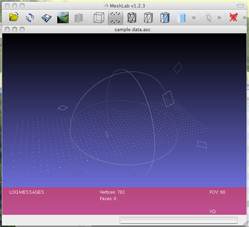 |
| Adding point landscape data to Meshlab. |
To convert the point data to a mesh (TIN) surface, I used the Surface Reconstruction: Ball Pivoting filter (in the Remeshing, simplification and reconstruction menu) with the default settings (world unit: 0.0, perc on 0.0, clustering radius: 20, angle threshold: 90). To see the result I had to click the Wireframe button in Meshlab to get a surface made of triangles. The file was saved in *.3DS format.
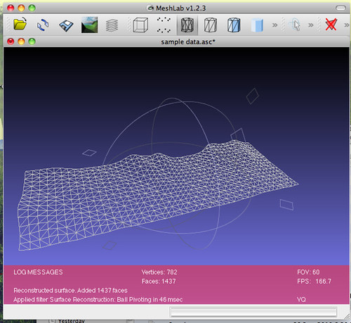 |
| Wireframe after meshing. |
The *.3DS file was then imported into Google Sketchup for modeling. Although the mesh seemed to act like a single object, attempting to use certain tools made me realize that it was being manipulated as a collection of triangles, which meant I couldn’t use such things as the Push/Pull tool to extrude the surface down to a lower plane to create a solid model. Luckily I found a Sketchup plugin to let me do something similar (available here). The Curviloft plugin allowed me to fill in space between a rectangular base (easily drawn in Sketchup) and the meshed landscape surface above it.
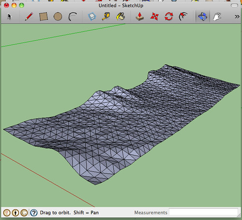 |
| Adding mesh to Google Sketchup. |
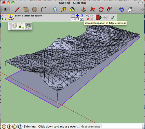
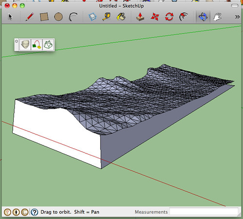
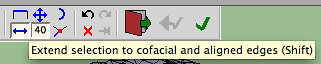
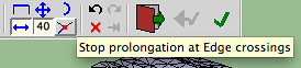
I used the Skin Contours tool on each of the four remaining sides to achieve a solid model. To do this, I drew a line connecting the corner of the base rectangle to the corner of the mesh above it. Once a side had been marked this way, I used the Skin Contours tool to select each edge of what the new face was going to be and clicked the checkbox. In order to select adjacent mesh edges, the Extend Selection toolbar button needed to be on, and the Stop Prolongation button needed to be off.
 |
| Adding a base and connecting it to the mesh at the corners. |
 |
| One side completed. |
To get the final file format correct (I’m hoping), I had to export the model from Sketchup as a COLLADA (*.DAE) file, then into Meshlab, and then use Meshlab to save into *.STL. I was told that my *.STL file needs to be “solid,” but I’m not sure whether this simply means “no holes” or whether there is a trick to completely fill the model with some virtual material (Unobtanium? Adamantium?). I’ll send this model to the Professor of Rapid Prototyping (not his real title, unfortunately) and see what sort of feedback he has. Tune in next time for the exciting conclusion!
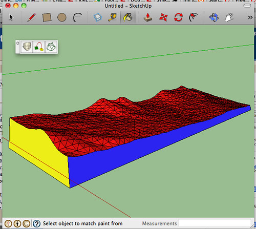 |
| The finished model in Google Sketchup. |
Total project time (including learning Sketchup and Meshlab and designing the workflow): several hours.
Writeup time: 1.5 hours