What’s Past is Prologue 1: Grand Forks Life and The City Beat

Although hopefully this blog will grow as a resource/meeting place for people who are interested in promoting complete streets in the area, it’s actually not the first Grand Forks blog to bring up streets-oriented issues.  Grand Forks Life, a blog that stopped being updated in 2009 (but is still up), had a number of posts on the topic:

Another area of discussion was the blog of Grand Forks Herald reporter Tu-Uyen Tran, The City Beat, which has not been updated since October 2010.  Tran is notorious for his attention to detail, not lacking in these relevant posts:

Unfortunately, a few years have gone by without any investigative blogging on the Grand Forks street scene, but this past coverage might give you an idea for what we should be thinking about right now and how things have changed–or stayed the same.

If you think we’ve missed a great post from another blog, or a great discussion in the local media, drop a link in the comments.

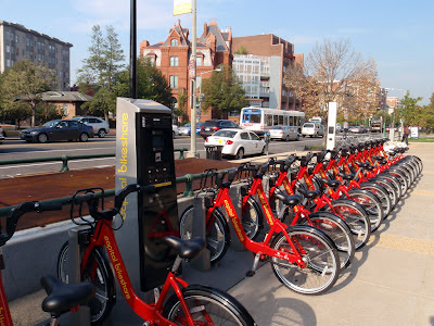
More Coverage of Possible Bikesharing System

Is something similar to Capital Bikeshare coming to Grand Forks, North Dakota?
(Photo by Daquella manera under a CC-Attribution license.)

Today’s editorial in the Herald has a few examples of similar systems (not just bikeshares) in place that are run by the government instead of the private sector and is generally supportive of the city considering (or even trying out) the idea.

The original story has already gathered over 80 comments, both for and against, but a number of those comments (as always) have to deal with the same tangential issues that always come up: how much the Alerus center cost, how bad the smell from Crystal Sugar is sometimes, and how people like to argue on the Internet.  I’m not going to count up the number in favor and against because I think the sample isn’t representative; the official survey closes today at five and I’m hoping for results next week.

Interestingly enough, New York City is only slightly ahead of us on the bikesharing front and are choosing where to place stations for a July launch.  They are following Boston, Denver, and Washington, D.C. as another large U.S. city providing this service as a partnership with a private company.  University of California, Irvine (about half the number of students as Grand Forks has people) has their own system.

Wikiposedly (and I have not had time to check), government-run systems do require subsidies in one form or another, typically through advertising on the bikes or sharing stations, however these monetary costs can be made up in other ways that benefit all residents: less automobile congestion, more exposure to the outdoors, more exercise, a stronger sense of community and, most importantly, transportation options.  Add to this the strong support Secretary of Transportation Ray Lahood has shown for cyclists and pedestrians, it seems like we may finally be entering an age where non-motorists can claim their space on the street as equal.

I’m not sure that bikesharing in Grand Forks will work, but the fact that we’re even looking into it is good news.  Who knows?  We could get something Fargo doesn’t have.

Bike share or bike rental in Grand Forks?

Update: Survey results are available from here (26 April 2012).

I was sent an email about the survey (open until 5 PM on April 13th, info) a few days ago, so I figured this Herald article was coming.  The news here is that the city (through Greenway Specialist Kim Greendahl) is entertaining the possibility of setting up either a staffed bicycle rental program (what I usually think of when I hear “bike rental”) or starting a bikeshare program (where riders could swipe a card at a kiosk, unlock a bicycle, ride it across town, and then deposit their bicycle in another kiosk).

I’ve only used one other bikeshare program, in Minneapolis last October, and I loved it because it let me get around as a visitor without needing to drive.  Does anyone else have experiences to share with this sort of system in other cities?

The specific target for any sort of bicycle-providing system seems to be visitors/tourists to Grand Forks.  I think this is exactly who would use a bicycle rental stand located on the Greenway: people from out of town who are looking for something to do.  A bikeshare system could mean a little more for residents because it would allow people to mix their transportation options: ride a bicycle across town in the morning when it’s sunny, ride the bus home if it starts to rain later.  Multiple kiosks mean multiple route possibilities and encourages people to ride.

What either of these systems does not do is get people to ride whose sole reason for not riding is lack of a bicycle.  If you look around, cheap bikes are easy to get, so easy that the racks outside the UND dorms are chock full and that the Mission always seems to be surrounded by riders.  It’s my hypothesis that supplying people with bicycles will not make them ride, and this is supported by ridership surveys for bikeshare systems such as the one in Washington, D.C.,* Minneapolis, MN, which is frequented predominantly by riders who already own another bike.  What a bikeshare system does is allow people the flexibility to choose the best form of transportation for their immediate needs: car, bicycle, bus, foot, etc., without needing to head back and reclaim a bicycle they may have left locked up somewhere.

Given the choice, I’m in favor of a bikeshare system because it has the potential to serve all residents, however I imagine that a “trial” bike rental stand on the Greenway would be a good way to measure tourist use.  Maybe a local business could step up to run such a thing, which brings me to my next question: how easy is it to rent a bicycle in Grand Forks, and where do you head for that?

*Originally I was remembering a post on Streetsblog about Washington, D.C. bikeshare, but that post was about comparing injury rates between bikeshare users and personal-bicycle users.

Columbia Road to be Widened

According to the Grand Forks Herald, Columbia Road will be widened to six lanes after a vote last week by the city council.

In another Herald article, we’ve heard city council member Tyrone Grandstrand suggest a six-lane option is overkill based on traffic patterns from the last ten years:

‘Grandstrand said the city should pursue projects that support mixed business and residential development and planning that supports public transportation rather than expect traffic levels to keep going up on business corridors.
“We’re going to have less traffic on Columbia and everywhere else,” he said.’

[Added 2012-04-09]
Grandstrand posted details of the traffic study in the Herald comments section:

I voted against 6 lanes but along with everyone else in Grand Forks I believe Columbia needed fixing a long time ago.  Columbia road traffic decreased by over 20% from 2000 to 2010. Along with traffic generally in Grand Forks, so people didn’t just pick a different road to drive on.  4 lanes, with intersection upgrades and some use of technology would have been just as effective and 1.1 million dollars cheaper. 

[end add]

The proposal presented to the city council can be found here (.pptx) and describes two phases of widening to occur: the first from DeMers Avenue to 11th Avenue South in 2013, the second from 11th Avenue South to 14th Avenue South in 2014.  The presentation contains a brief description of the current non-motorized facilities along this stretch of Columbia Road, which include a sidewalk to the east and a wider shared-use path to the west.

No official discussion has been heard yet of on-street bicycle lanes as part of this project.  There are four shared-use/driveway/street intersections between the Columbia Road/DeMers Avenue overpass and 14th street south, a distance of about half a mile.


First Post [GFK Streets]

Hello World! More updates to come.

Please post a comment if you are interested in contributing.  For the record, I’m hoping this can be a space for all stakeholders in safe, efficient streets in Grand Forks, so as long as you live here and have a thoughtful opinion, it doesn’t matter whether you identify as a pedestrian, cyclist, driver, something else, or any combination thereof.

If you are looking for a copy of any of the articles referenced, you can drop a comment with your email address and we can get that to you as well.  Some of the local media drops behind a paywall rather quickly.

GIS: Raster cell centroids as vector points with GDAL and R

Short intro: I’m using raster data for part of my dissertation, but I’m storing the paleoenvironment data in a database as the latitude and longitude of the center of each grid cell. This lets me query my environment localities, add new ones, and make specific datasets.

Sometimes I take existing maps of other people’s environmental interpretations and digitize them, leaving me with vector polygon data. I need to convert the polygons into the same kind of data I’ve been storing. This is surprisingly hard in both QGIS and GDAL alone, so I finally figured out how to do it in R today courtesy of Simbamangu over at StackExchange.

See the attached images for how things look at each stage.

Below are the general terminal commands, first in GDAL and then R. I will try to add more rationalization and explanation later. My operating system is Mac OS X but these should be modifiable.

GDAL in your terminal

gdal_rasterize -at -where 'freshwater = 1' -a freshwater -ts 360 180 -te -180 -90 180 90 -l "source_layer_name_in_shapefile" "shapefile.shp" "output_raster.tif"
Produces a geoTiff of your input polygons where the attribute ‘freshwater’ is equal to ‘1’. For more detail I invite you to read the GDAL documentation, it’s quite good.

R

To run through a single file:
# load necessary libraries
library(maptools);
library(raster);
library(rgdal);

# Load the raster from a file
r <- raster("rastername.tif") # Convert to spatial points p <- as(r, "SpatialPointsDataFrame") # Set name of column of raster values for later use names(p)[1]<-"value" # Get only the values we want (values above zero) in that column psubset<-subset(p,p$value>0);

# Save as a shapefile (extension appended automatically)
writeSpatialShape(psubset, "outputfile");

You can also loop through a directory:
# load necessary libraries
library(maptools);
library(raster);
library(rgdal);

# Set working directory
setwd("/my/working/directory/");

# list all .tif files in working directory
for (file in dir(pattern="*.tif")) {
r <- raster(file); p <- as(r, "SpatialPointsDataFrame"); # Set name of column of raster values names(p)[1]<-"value"; # Get only the values we want (values above zero) psubset<-subset(p,p$value>0);

# Make a new filename
oldname<-substr(file, start = 1, stop = nchar(file) -4); newname<-paste(oldname,"pts",sep=" "); # Make a shapefile writeSpatialShape(psubset, newname) ; # Make a CSV file # Convert to data frame so you can drop extra columns psubsetdf<-as.data.frame(psubset) write.table(psubsetdf[,c(2,3)],file=paste(newname,".csv",sep=""),sep=",", row.names=FALSE); }

Ephemeral ladybug trace fossil

I just came across this image of a ladybug making tracks in condensation on a window. As far as I can tell, this is an original photo by user 77dlsd at reddit. Fascinating! This might be a decent way of capturing different kinds of arthropod trackways, although you may have to be something of a Snowflake Bentley to frost a glass plate, drop a critter, catch a critter, and photograph the plate without losing anything.

[notes] Converting MRSID to GeoTIFF using GDAL in Mac OS 10.6 (Snow Leopard)

Just found out how to convert MrSID files (from NZ geology) to other formats using GDAL.

  • Followed instructions here: http://www.photo-mark.com/notes/2008/nov/12/converting-mrsid-gis-files/
  • Needed most recent version of GDAL with frameworks (1.8 Complete): http://www.kyngchaos.com/software/frameworks
  • Had to change command to “/Library/Frameworks/GDAL.framework/Versions/Current/Programs/gdal_translate -of PNG /Users/Matt/Desktop/whangarei/inputmap.sid /Users/Matt/Desktop/whangarei/outputmap.png”
  • That makes an image file, but I think I’ll convert to geotiff for GIS:
    • /Library/Frameworks/GDAL.framework/Versions/Current/Programs/gdal_translate /Users/Matt/Desktop/whangarei/inputmap.sid /Users/Matt/Desktop/whangarei/outputmap.tif
  • Map source: http://www.gns.cri.nz/Home/Our-Science/Energy-Resources/Geological-Mapping/Geological-Maps/1-250-000-QMAP/Map-downloads
  • Map coordinate system: New Zealand Map Grid (Geodetic Datum 1949)
  • gdal_translate man: http://www.gdal.org/gdal_translate.html