Quick Rainmeter Snow Skins

I’m a minor nerd about fresh snow, so I have theseĀ Rainmeter skins running on my monitor right now (really just two versions of the same skin). I thought I had them in GitHub or GitLab, but apparently not yet. If you use them, enjoy!

Two snowfall maps in two different Rainmeter skins.

Snow.ini

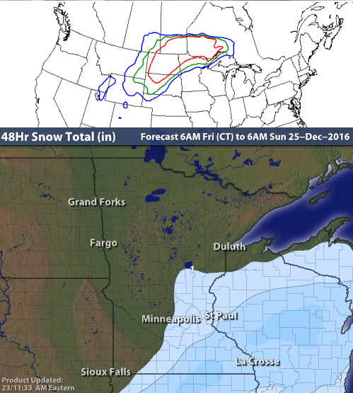
;Shows the 48-hour snowfall map from Intellicast.
;To customize, go to http://www.intellicast.com/Travel/Weather/Snow/Forecast.aspx?region=brd, navigate to the right region, and get the url of the image.
;Paste that as URL, below.
;
;Help from http://rainmeter.net/forum/viewtopic.php?f=5&t=20018 and http://docs.rainmeter.net/manual/getting-started/creating-skins

[Rainmeter]
Update=3600
;To make this to immediately show up, change value to 0 and refresh.

[MeasureImage]
Measure=Plugin
Plugin=WebParser
URL=http://images.intellicast.com/WxImages/48hrSnowForecast/brd.jpg
Download=1

[MeterImage]
Meter=Image
MeasureName=MeasureImage
H=375
W=500

snow_noaa.ini

;Shows the 3-day snow probability from NOAA.
;To customize, go to http://www.weather.gov/crh/outlooks?sid=fgf#.WF2NTdUrJaR
;Paste that as URL, below.
;
;Help from http://rainmeter.net/forum/viewtopic.php?f=5&t=20018 and http://docs.rainmeter.net/manual/getting-started/creating-skins

[Rainmeter]
Update=3600
;To make this to immediately show up, change value to 0 and refresh.

[MeasureImage]
Measure=Plugin
Plugin=WebParser
URL=http://www.wpc.ncep.noaa.gov/wwd/day3_psnow_gt_04.gif
Download=1

[MeterImage]
Meter=Image
MeasureName=MeasureImage
H=375
W=500

uMap is the best web-GIS alternative to Google Maps

Really.  You should try it.  http://umap.openstreetmap.fr/en

Pros:

  • Can split lines (Google Maps can’t).
  • Can move features to different layers (Google Maps can’t).
  • Can have advanced attributes, line styles.
  • Can see distances plotted with features.
  • Can turn layers on and off.
  • Can import data ()GPX, KML).
  • Can limit who can see and who can edit.
  • Uses OpenStreetMap, so if you know your GPS is right and the basemap is wrong, you can change the basemap.

Cons:

  • No satellite imagery basemap.
  • Can’t switch layer display order (but can duplicate layers, might be possible to change order that way).

I haven’t played with everything, but I’ve built a map for a race I’m directing and I’m sharing this with the participants.

Wanted: Geologic maps (formation contacts) of South America countries, ideally for use in GIS

Here’s a good ol’ plea for help from the scientific community. As my questions to “the scientific community” via Academia.edu have gone unnoticed, I’m posting this out here to see if anyone else searching for the same thing has had any luck. [Since then, I’ve discovered ResearchGate, which I generally like better for questions like this. 2014-03-05]

I’m building a GIS (geographic information system) model to determine the possible biogeographic districbution of a genus through time. What I need for this, since the fossils are from South America, is a good geologic map, either of most of the continent or of the countries of Brazil, Argentina, Ecuador, and Peru. Hunting around online hasn’t shown me anything that I want to shell out a bunch of money for, site unseen, and I’m honestly trying to avoid having to scan paper maps and register them (additionally, I haven’t been able to access our worldwide collection of paper geologic maps recently).

1:500,000 or 1:100,000 would be great, but I’d even take 1:1,000,000 at this point. I need something with formational contacts so I can plot possible distributions.

So that’s the challenge of the day: have any geologists in South America discovered a good source for this type of material? Would you be willing to share or trade?